
Return to main Vanishing B.C. page Return to home page
This page last updated July 15, 2017
© Michael Kluckner
| A
collection of sketches of modest houses, all 100 years old or so,
marooned in supercharged Vancouver, that I have added to from time
to time for the past 15 years. They're not especially historic, in
most cases, but they have "the look" of a shabby, appealing
Vancouver – a place where things could grow old disgracefully –
that has always attracted me as a painter. |
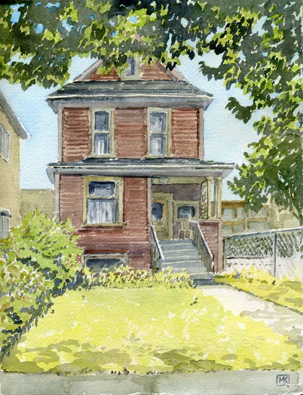 Summer of 2013: a ramshackle rooming house across the street from the Western Front artists' centre – the former Knights of Pythias Lodge. Its address is 316 East 8th, which originally appears in the 1900 directory as 318 East 8th (if it is this house, there was no building permit required before 1901), and according to VanMap had a "major improvement year" (converted to a rooming house, likely) in 1929. The water permit card for its lot (W.1/2 of 3, Blk 54) doesn't seem to exist. 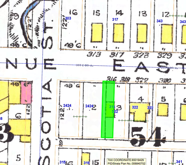 The 1912 Goad's overlay on VanMap shows the house and, in the top left corner, a section of Brewery Creek; probably the creek had only recently been put into a culvert on lots 1 and 2, just west of 316 East 8th, and nobody was yet game to build on the fill. The Knights of Pythias built its hall on Lot 16 in 1922. ***************** 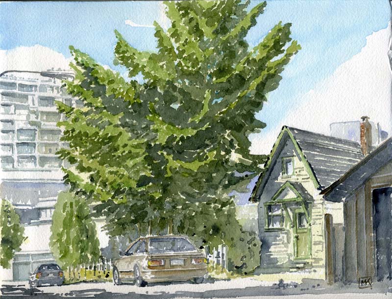 Summer of 2013: There is a small cottage, visible on the south side of 12th Avenue just west of Kingsway, occupying an overgrown lot. The property was vacant; I wandered around it, trying to find an angle to paint, and finally settled on "removing" a tree from in front of it and sitting in the lane, looking northeast. It was the only point of view other than an extreme close-up where you could see the front door. 336 East 12th first appears in the 1911 directory as 333B East 13th (formerly known as Dublin Street until District Lot 301 was absorbed by Vancouver in 1911). The smoothing of 12th Avenue, indicated on the map, was completed in 1927 – indicated in the water permits by notations of "3 houses on same service" and "new main on 12th, 1927" – before the 1928 Harland-Bartholomew Plan identified a number of other road alignment improvements elsewhere in the city (such as 12th to 10th at Trafalgar-Macdonald and Commercial Drive at Venables-Adanac). It has left the cottage partially visible from a very busy part of 12th. Nathaniel Twigg, a motorman with the BC Electric, may have been the first occupant. Twigg (spelled Twigge or Twiggie in various directories, poor bugger) earlier lived at 335 East 13th. 333 (just a single home for the address) is vacant in the 1908 and 1909 directories. Nathaniel Twigg, his wife Kathleen and daughters Mary and Adelaide are listed in the 1911 census as living at 333B East 13th. They were naturalized Canadians and Baptists, originally from the UK. 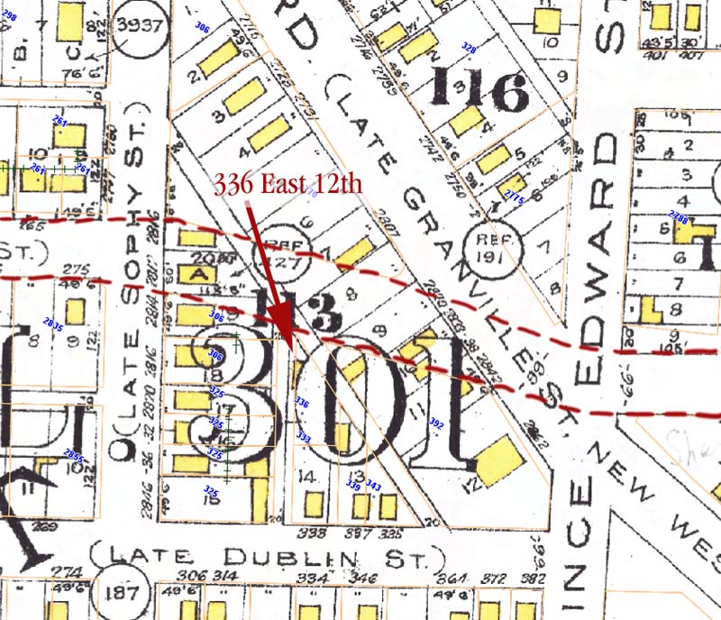 *******************
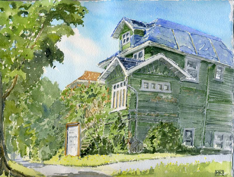 Summer of 2012: The Green House, the former presbytery for the Grandview Methodist Church at 1885 Venables, used for almost 40 years as administrative and rehearsal space for The Cultch, had been declared uninhabitable and was effectively abandoned – the board of the Vancouver East Cultural Centre had not done any maintenance on it for years, intending to replace it with a new building. This all changed in 2014 when the city decided to rehabilitate the building and use about $900,000 it had set aside to contribute to the replacement fund for repairs and upgrades. The building was then tarped up; at this writing in 2015, no work has commenced but the building is secure. 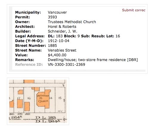 ************************
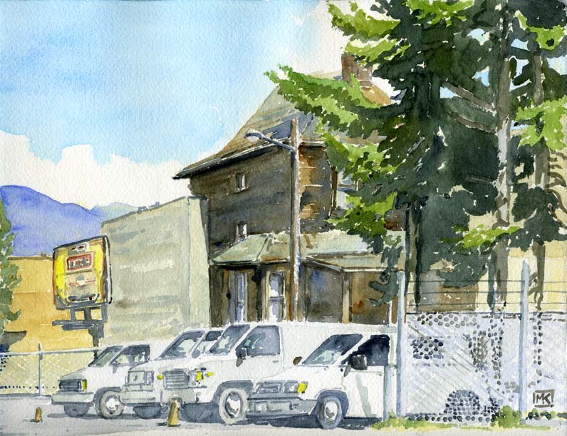 Summer of 2013: 350 East 10th, a "buried house" with a storefront attached to it that recently was home to a café (boarded up in late 2015), across the street from the Kingsgate Mall (the site of Mount Pleasant School). 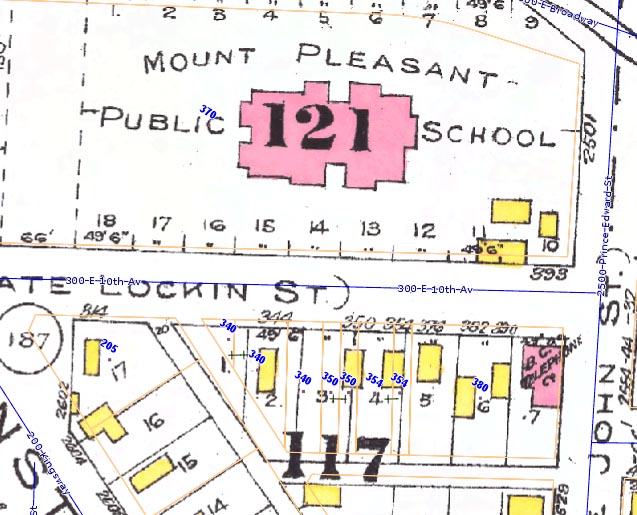 It is probably the house that straddles Lots 3 and 4 on the 1912 Goad's map (above); its design indicates something pre-1910, probably, and it doesn't appear on the 1905 Goad's map. My guess is that was moved to sit squarely on Lot 3 in the 1920s (water permit #24928); the other records, both plumbing and building permit, from the block are sketchy to say the least. It's one of a handful of buried houses left in Vancouver – houses built on residential streets that became commercial ones. Some additions of storefronts to such houses occurred in the 1930s, a strategy both to adapt to the new commercial reality and also to generate revenue during the hard years of the Depression. The watercolours below are from "Vanishing Vancouver: The Last 25 Years" and were painted in 2010 and 2011: 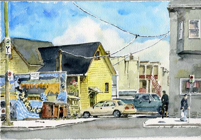 From Fraser Street, looking into the lane south of Broadway at the rear of an 1897 house, hidden behind the Launderama shopfront since 1932. The shop was a grocery store until 1960, when it became a laundromat.  2052 West 4th Avenue, built in 1905, had a shopfront added to it in 1927; the latter was Snowflake Cleaners and Dyers in the 1930s, Dob-Sin Cleaners in the 1940s, a manufacturer's agent in the 1950s, a company called Rendell-Paret which sold do-it-yourself radio and electronics equipment in the 1960s, and a poster shop serving the hippie community for a time thereafter. From Conor Brandt, 2017: I lived for 6 years (2006-2012) at 2052 West 4th Ave and was excited to see it included in your work. It was a house rented by friends, passed along from roommate to roommate for more than a decade. It was all single dudes that was pretty run down on the inside (we had rats, raccoons that lived under the kitchen floor, and even a skunk who lived under the house at one point) but it was in the best location on 4th Ave near the beach, cheap rent, and we could party and make noise at all hours because of the lack of neighbours. I worked at Long and McQuade and would get free speaker and light rentals so we would throw some epic parties. It is so cool to see the house captured in your image. What makes it even more special is that my Mazda 323 with the For Sale sign in the windshield parked behind the house is in the image. I have many special memories of living in that house. I play in a band that started there. We rehearsed in the attic. The house was nicknamed "The Rampant Lion" after an old pub sign (made by the poster shop you mentioned) we found abandoned in the alley. Therefore that is the band's name. You can check us out here if you like http://rampantlion.bandcamp.com  Buried houses, built respectively in 1937, 1921 and 1926, just south of 1st Avenue on Renfrew, which became a commercial crossroads because of the stop there of the Burnaby Lake interurban line. ****************************************
 Summer of 2014: the former CPR Superintendent's house sits at the top of a steep lot, behind a stone wall and hidden by an overgrown bedraggled garden and tall trees, at 1550 Marpole Avenue just west of Granville in the First Shaughnessy neighbourhood. It was built in 1910, right at the beginning of the settlement of Shaughnessy, for Francis Ferguson Busteed, and occupied by two of his successors until 1946. It was subsequently a rooming house and has received little maintenance; a redevelopment proposal a couple of years ago would have seen only the front façade retained. It still sits derelict, a testament to the push and pull of land speculation and the clash between the city, which wants historic houses like it retained and renovated, and some new owners who want demolition and new mansions. 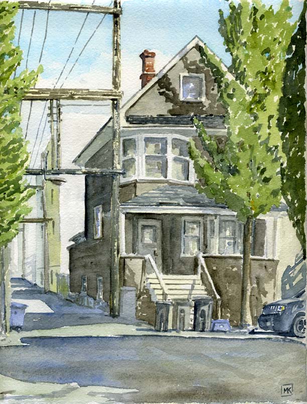 Summer 2013: 2162 Ontario, one of a handful of surviving houses in the Lower Mount Pleasant industrial area. House set sideways at the rear of a 49'6" lot. Francis Wright, stationer, at "2102" in the 1909 directory. The water permit was signed by James Haughton in 1907. 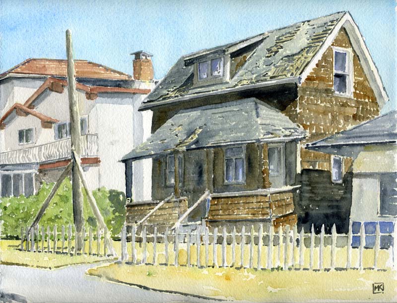 Summer of 2013: 4966 Rupert Street, way out in East Van (the old Municipality of South Vancouver) but close to the Collingwood West Station of the Vancouver-New Westminster interurban line running along Vanness Avenue – today's right-of-way for the Expo SkyTrain line. Its water permit is SV1778, a 1910 number, but the permit no longer exists, and I can't find a building permit. From the 1912 map (below), it looks like the house, or a house, was built at the back of the lot; the design is really Pioneer Style, with side gables and an attached, hipped-roof porch. It looked like it was about to be demolished – I haven't been back since. 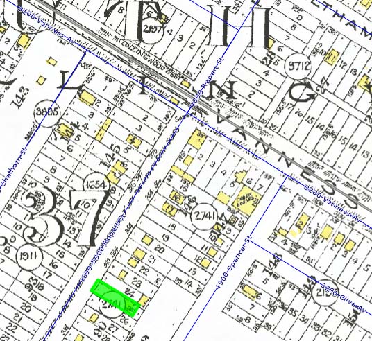 |
Above, 815 Drake in 2010 and, below, what it looked like a decade
earlier. It was demolished in 2014.

***********
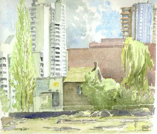
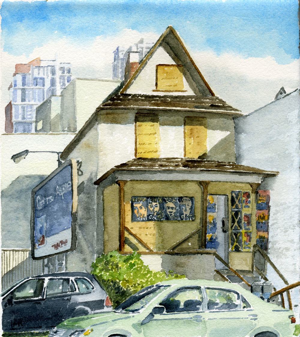
| 2000: Howe Street south of Davie – the old house behind the Odyssey nightclub at 1237 Howe has only become visible because of the demolition of the buildings to the north of it. The lot has been vacant now for a few years, creating an opportunity for a billboard – to catch the eyes of motorists on busy Howe Street – which Century 21 Realty uses, featuring an ad with the slogan "Isn't It Time For the Home You Really Want?" The last few poplar trees and the last weeping willow in the downtown share the lot, too. |
More to come, maybe.