Return to main Vanishing B.C. page Return to home page
This page last updated January 22, 2011
© Michael Kluckner

|
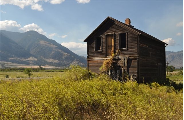
Written/sketched in 2001: The Elton home is a forlorn landmark on the east side of Highway 3 south of the little community of Cawston, a few miles past Keremeos in the Similkameen River valley. The picture above looks south and east toward a cleft in the hills through which the highway passes, eventually crossing the Richter Pass before descending steeply through vineyards and orchards to Osoyoos Lake. The highway is on the extreme right of the scene, as was (until the tracks were removed) the Burlington Northern Railway, originally the Vancouver Victoria & Eastern Railway, a part of the American Great Northern Railway system. The rail line was laid in 1907, three years before Elton built his house, linking the valuable coalfields around Princeton and the local mines, especially the fabulous Nickel Plate Mine at Hedley, with the Great Northern's hub at Spokane; the commercial battle between the Great Northern and the Canadian Pacific Railway for the wealth (mainly mineral) of the Boundary country led the latter to build the legendary Kettle Valley Railway connecting Vancouver with the Kootenays. Highway 3 east of Princeton runs on the old VV&E roadbed along the Similkameen River--following damage to the rail line from flooding, the tracks were removed there in 1939. Ralph Elton was born in India where his father was a colonel in the British army, moved to England as a child, and subsequently migrated to southern Alberta where he lived before settling here. Although one can imagine his house as the centre of a large "spread," Elton in fact owned just eight acres around it, with another eight of pasture in the hills behind. On his little farm he had apple trees, chickens and horses, but his main source of income was work on the roads. His daughter married into the McCurdy family, who had moved west from Owen Sound, Ontario and settled in the valley in 1878, and the Elton house now sits on the McCurdy Ranch, a much bigger operation that over the years has raised cattle, sheep, chickens and fruit crops. The second McCurdy house, built in 1895, still stands across the road from Elton's, but is disguised by later additions and modern cladding over its squared-log sides. The McCurdy Ranch has presently 11 acres of orchard and 120 cows; its roadside sign advertises prunes for sale in the fall. It was on such a September day that I sat by the roadside and painted the picture above. Thanks to Don McCurdy of the McCurdy Ranch for the information about his family. Although today many of the benches and river-bottom fields are planted with vineyards and orchards, Cawston was historically a centre for horse and cattle ranching. During the summer, cattle thrived on the bunchgrass of the high benches and were overwintered on the pastures along the river. Mining camps and railway construction provided local markets for beef, while the markets of the Fraser Valley and Vancouver were reached by cattle drives over the Hope Trail. Once the Kettle Valley Railway reached the coast in 1915, cattle were driven across the mountains to Penticton for shipment; when the railway subsequently reached Okanagan Falls, a stockyard was established there which further shortened the cattle drive. One legendary rancher was Manuel Barcelo, a Mexican who had come north from California to Yale with the goldseekers in the 1850s and established himself as a pack-train operator in partnership with Henry Hunter, a merchant in Hunterville, a vanished community west of Hope. (Hunterville was a post office, with Hunter as the first postmaster, 8 mi northeast of Agassiz and 1 1/2 mile from Ruby Creek on the north side of the Fraser River; although it was in operation from Oct 1907 until May 1912, it doesn't appear on my 1914 provincial government Lands Department map, so it obviously vanished rather promptly!) They drove their cattle across the "Hope Trail," which evidently was synonymous with the Dewdney Trail – see Foundation Mine cabins for the route. Having married Hunter's 18-year-old daughter Lucy (who was allegedly about the same age as Barcelo's grandchildren in Mexico), he obtained 280 acres northeast of the Cawston Indian Reservation (IR 6), drove cattle north from Guaymas and established a ranch. The Barcelos became known both for their cattle and the excellent horses they bred, in demand both for riding and for hauling the stagecoaches and freight wagons that provided all the transport before the railway arrived. Apparently there were about 80 freighters running four- and six-horse teams from the transportation hub at Penticton, hauling loads through the ranching and mining country, most notably on the Green Mountain Road, the one that today goes to the Apex Mountain ski area, to take supplies to and remove gold concentrate from the Nickel Plate Mine above Hedley. Another significant rancher on the land between Keremeos and Osoyoos was Francis Xavier Richter, born in Austria in 1837. He arrived in the Boundary country in 1864, having driven 42 head of cattle north through the American Okanogan and through the Canadian customs at Osoyoos. The Richter Ranch eventually grew to about 10,000 acres in the Richter Pass area. Frank Lake and Richter Lake, both visible from Highway 3, recall the family's settlement; Richter's second marriage in 1894 produced five daughters and a son, Frank Jr., who served as MLA for the Similkameen in the 1950s, including a time as Minister of Agriculture in the WAC Bennett government.
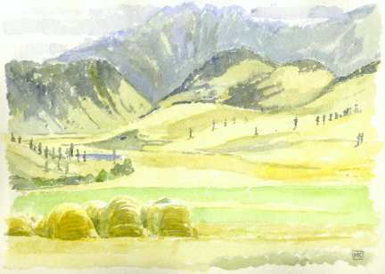
Richter's house on the home ranch, built in the 1880s, had a sweeping view south and west across Frank Lake toward the dramatic Cathedral Mountains of the Okanagan Range. It apparently burned down in 1986. The view today is unchanged from Richter's time, with huge "loaves" of hay stacked at the edges of the fields. The lakes in this arid area tend to dry out in the summer, none more dramatically than nearby Spotted Lake. My source for the historical material on the Barcelos and the Richters is Okanagan Roots by Doug Cox, Skookum Publications, Penticton, 1987. Note from Marilyn Roberts,
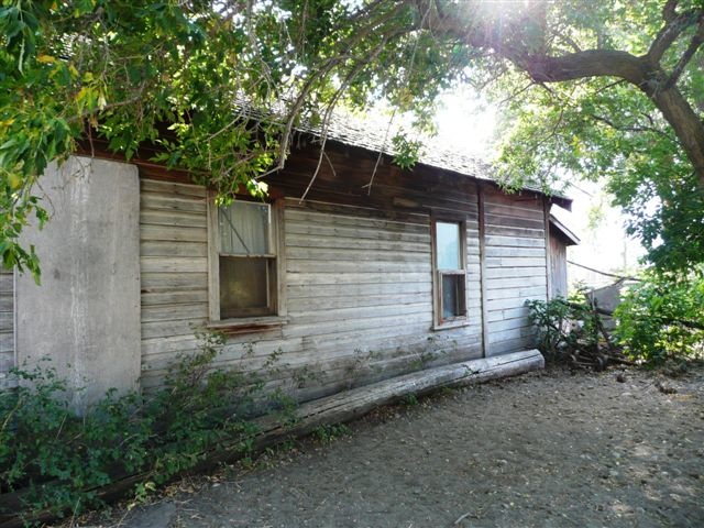
2010: A woman who lives near the covered bridge in
Keremeos drove me to the house you painted in Cawston, and asked
permission from the son to take pictures of the house, and also
the small house across the highway. Boy, the trees are
sure taking over! (this house across the street belonged to
the eccentric sister, apparently they both came from
England.) I was there at a bad time for lighting. I
took pictures even though it was in the shade.
Beautiful old wood sides, real character! I would like to
say that your book was like a "passport". I am
hoping to continue my adventures next summer. |