Return to main Vanishing B.C. page Return to home page
This page last updated March 8, 2019
© Michael Kluckner
2001: Doukhobor Village on a bench on May Creek Road, within sight of Highway 3 in the hills just west of Grand Forks. The complex consists of two very plain, two-story brick houses, facing each other across a courtyard with a smaller, wooden building at one end forming a "U," plus the remains of some outbuildings for livestock. In reality, the roofline of the house on the left has been altered more than 20 years ago with a huge dormer, and the property is now used for "eco-camping." In a 1981 study for the Minister of Municipal Affairs entitled Doukhabour Heritage, author D.W.L. Tarasoff, described the village as "unique," the "last village with both communal houses and various wooden outbuildings." At the time, one owner of the property named Podovinakoff was suing the other owner, Matheson, over their respective shares in the property and future plans; Tarasoff recommended that the B.C. Heritage Trust acquire Podovinakoff's interest in the property for about $40,000 and thereafter encourage Matheson to restore the property. Evidently, nothing was done. The property was for sale in the late '90s for $329,000. The wooden buildings forming the end of the courtyard appear to be in ruins. According to Tarasoff's site drawings, the brick houses were 30' x 40', the same dimension as the Ootishenie house floorplans drawn below.
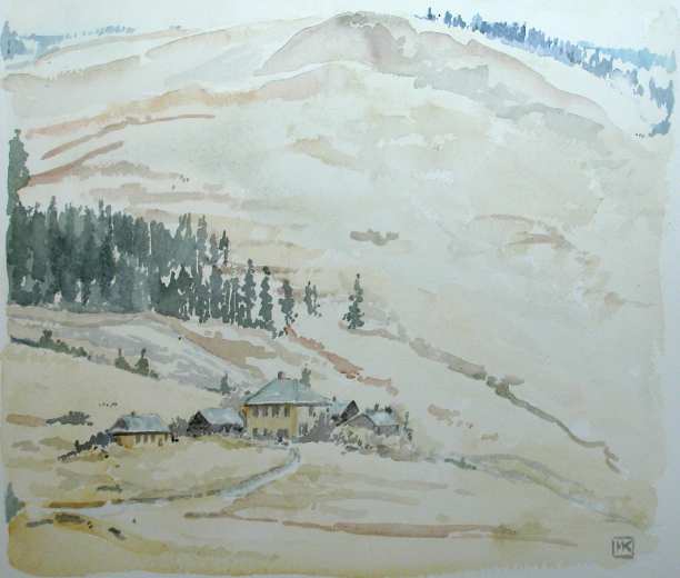
2002: Late fall, waiting for snow: the single remaining house of the Doukhobor Village on Hardy Mountain Road, over the hill north of Fructova, Grand Forks.
This is a 1912 building, open sometimes as the "Mountain View" Doukhobor Museum.
Another village even higher up Hardy Mountain Road near the junction of Reservoir Road, which crosses Hardy Mountain on its way to Fructova and Grand Forks' main valley, on the same chilly late-November day.
Photo 2018 of the May Creek Village: the roof burned off one of the two buildings and an infill cabin.

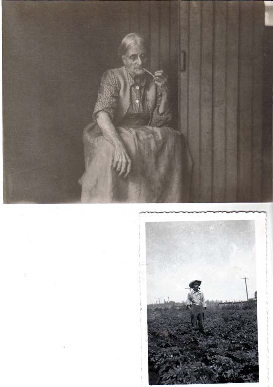
Note from Shawneen Edwards, 2008: I have enclosed photos of my grandfather E.B. Hardy standing in one of his potato fields. The other photo is of my great grandmother Hardy (E.B. Hardy's mother) on Hardy Mountain sitting in front of their cabin. This is the only photo i have of my great grandmother and all I know about her is that she was my dad's grandmother and the photo was taken on Hardy Mountain. When our family attended the opening of Hardy View Lodge in the 1980's our father donated a painting of the exact photo of great grandma Hardy to the lodge. In my research of Hardy View Lodge recently I had read that the lodge was going to be shut down for good, if it is I was wondering if the people at Hardy View Lodge would donate the painting to the museum as when we donated the painting to the lodge all of the imediate Hardy family signed the back of the painting.
My maiden name is Hardy.The Doukhobors bought the land in Grand Forks from my grandfather over a handshake and every month they sent money to my grandfather to pay for the land they bought from him.
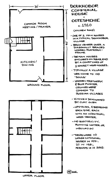
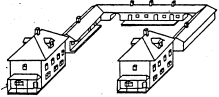
I drew the floorplans on the left in November, 2002, of the remaining, burned out communal house across the river from Castlegar near the airport. The drawing below, by Edward Gibson, was part of a 1976, unfinished report for the Canada Council, showing "Ootichenia" (as he spelled it) and describing it as a typical community village for 75 to 100 people. The village was abandoned even then.
Perhaps surprisingly, given their non-materialistic beliefs and simple ways, the Doukhobors decorated their building with elaborate wooden fretwork or scrollwork. This example of the Danshin Village communal house on Danshin Village road (west of the May Creek Road village illustrated above) appeared in the 1986 Grand Forks Heritage Inventory by Robert Hobson and Associates. Note also the distinctive brick, produced at the Doukhobors own brickworks, with its hollowed-out centre. The bricks are always a tawny brown colour.
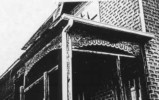
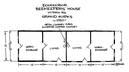
Beekeepers Cottage, Victoria Road, Fructova, c. 1910, painted in 2001. Regrettably, this decorated little building is falling to pieces, its porch spindles, posts and fretwork brackets all deteriorated, and its brick skin slipping. Although it is an absolutely tiny building, as seen in the floorplans below, it is actually two separate dwelling units sharing a common chimney. It stands at the back of a field on a small farm-holding with a modern house near the road, and is used for storage. If the upstairs was used as a sleeping loft, it must have been accessed by ladder through a trapdoor.
See also the Brilliant Bridge page for further sites and links.
The photo from about 1950 by an anonymous Provincial Government photographer appears to be from the area around Reservoir Road in Fructova--that is, west of the town of Grand Forks in the valley. Hardy Mountain is on the left; the Beekeepers Cottage is probably in the cluster of buildings in the left-centre distance. If I'm correct in my positioning of this photo, the 1929 Doukhobor School on Reservoir Road at Spencer Road is out of the picture to the left.
(Photographers unknown)
| Notes
from Jon Kalmakoff: I am a Doukhobor family and local
history researcher and writer, and developer of the Doukhobor
Genealogy Website (www.doukhobor.org).
I have added links from my website to your articles on the
Brilliant Bridge and other stories with tie-ins to the Doukhobors.
I am wondering if you have any information with respect to Porto Rico. The Doukhobors had a presence there in the 1920's and 1930's and I am in the process of trying to put together an article which summarizes the history of the settlement. 2019 from Andrei Conovaloff: updates on basic entries for three "forgotten" BC lumber towns with a Doukhobor connect, Porcupine, Porto Rico and Hills. See the following links: Porcupine
Porto Rico
Hills
AND
Doukhobor-Russian Reflections
is now off-line.
|
| |