Turkey & Greece 2005
Turkey & Greece 2005
Return to main travel page Return to home page
Return to the first Turkey-Greece trip page
Return to index
Scroll down to see the next one
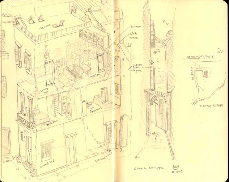
The house we rented in Hania, Crete -- a tall, narrow old building from the Venetian era of Crete's tumultuous history.
Return to index
Scroll down to see the next one
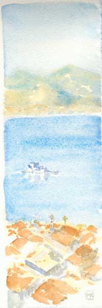
Hania is Crete's second largest town, developed mainly by Venetians, although there was a period of Ottoman occupation, with a large modern town and port nearby.
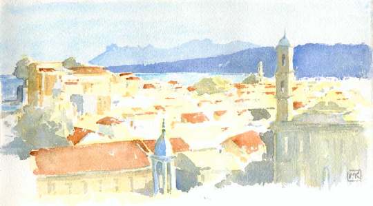
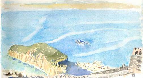
At the southwest corner of the surviving fortifications ringing the old town, there is a circular redoubt that provides a viewpoint. Early in the morning of October 29, I sat on the wall there and looked east at the sun-drenched, late summer city and distant coastline.
[on damp paper, patches of cadmium yellow deep as an underpainting; the background blues were painted next, "reserving" the negative space of the towers; later roof detail is burnt sienna mixed with cadmium yellow]
Return to index
Scroll down to see the next one
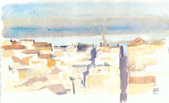
Same place as above, just as the sun was setting, but looking north toward the lighthouse, with the breakwater of the ancient harbour just visible.
[the shadows are purple -- i.e. rose madder mixed with ultramarine; building shapes are blocked in with cadmium yellow deep, yellow ochre, burnt sienna and Indian red; the distant, rather opaque sky, heralding a windstorm the next morning, is cadmium yellow deep and rose madder washed over wet manganese blue, with a strip of cerulean blue pushed into it before it dried.]
Return to index
Scroll down to see the next one
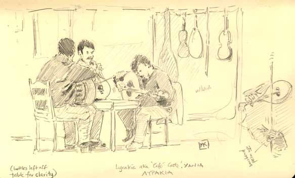
The Lyrakia cafe, near the old shipyards (the Enetika Neoria) on the Hania waterfront, is a centre of Cretan folk music. Jam sessions most nights with a mix of players, a lot of rhythmically complex laments and ballads and a really engaging, hypnotic sound. It seemed to me that the standard Cretan ensemble was two guys playing laoutos (the long-necked lutes) and one playing the lyra (the pear-shaped fiddle; the bow hand is always palm up). One or more of them would sing. It was a blast: for 6 euros, I recall, we were given a plate of olives and bread and a carafe of wine, and at one point a few of the locals danced. This wonderful music became our staple on the radio at our place: Studio Alpha, an FM station playing folk music round the clock.
Return to index
Scroll down to see the next one
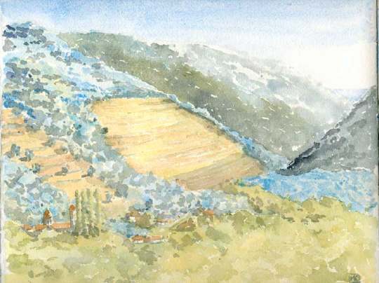
For the last few days on Crete, we rented a small Citroen and set out to explore the island. Day 1: the long winding road to Elafonisos at the southwest corner. At Vathi, a tiny spot where the road begins to descend from the central mountains toward the sea, I stopped to paint. Much of the ground is terraced. Olive trees are the native forest on high ground; chestnuts, just beginning to change colour, occupy the valleys. The distant hills are even drier and rockier, the vegetation a green-gray "garrigue" like much of the Mediterranean. In the distance, the blue triangle is the Sea of Libya.
Return to index
Scroll down to see the next one
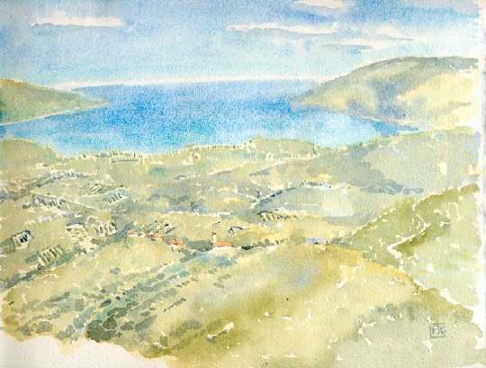
At a dot on the map called Malathyros, in the mountains behind Kissamos, we stopped to eat lunch on the roadside and gazed across the vast rolling landscape of olive groves and villages toward the Gulf of Kissamos. The view looks north toward the Sea of Crete near the northwest corner of the island.
Return to index
Scroll down to see the next one
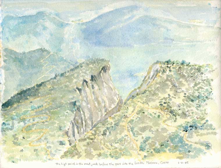
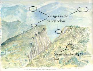
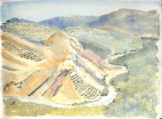
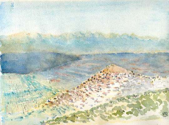
Day 2, took a long trip on the national highway, which follows the north coastline from Hania to Iraklio and eastwards. Our destination: the Lasithi Plateau, a mountain-ringed patchwork of farmland 900 m. above sea level. It was interesting in its own way, but the trip through the mountains to the entrance to the plateau was fantastic. I became almost a mapmaker in the watercolour above, which looks north toward the Sea of Crete. It was the roughest landscape imaginable, a "garrigue" of low thorny bushes with the occasional twisted olive tree, a jumble of rocks (much of it pummice from the ancient volcanic eruptions that, among other things, destroyed Knossos and the Minoan civilization) and wild precipices. Yet in the midst of this wild fastness, there is always the clonking sound of goat and sheep bells, with flocks scattered across the landscape and grazing on the almost vertical slopes, tiny villages and scattered shelters. I have never, in all my travels, seen such a combination of stupendous natural landscape with so many layers of culture and settlement. If you go, stop at the Taverna Kares in the tiny town of Krassi for traditional Cretan food -- the young woman who co-owns it is Swiss-French, so she speaks a little English as well as French, German, Italian and, of course, Greek.
Return to index
Scroll down to see the next one
Day 3: on another route, south from Hania toward the Omalos Plateau (less impressive than the Lasithi) and the entrance to the famous Samaria Gorge, a hike we will save for another trip. On the way, the road climbs steeply through sun-washed groves of lemons and oranges, changing to platted-out olive trees as the road climbs higher and the land gets dryer. Past Fourne, the rough slopes are all terraced, with the steepest ones clothed in a mauve heather, plus lavender and rosemary. Chestnuts fill the valley bottom.
Return to index
Scroll down to see the next one
Nafplio, another Venetian port on the Peloponnesse and the port for Argos. Expensive, but a very pleasant place to spend several days. Its hulking, wooded former acropolis guards the old town. Above it all is a rock outcropping on which the huge Palamidi fortress sits. Floating like a ship on an islet in the harbour is the curious, medieval Bourtzi fort (ironically, the only reason I had ever heard of Nafplio, because a photo of it was one of the scenes on the "Visit Greece" placemats in every Greek restaurant in western Canada for years).
My painting of the Palamidi fort was less successful than planned, so it's not worth putting here, alas. But the view from the Palamidi looking over the acropolis, the town and the harbour is so precipitous that I had to draw it, although I had a real problem with vertigo looking back and forth between the close-up paper and the scene so far below. Anyway, these watercolours were done in the hotel room that evening after we descended the 850 or so steps down the cliff to the town.
[The water is the biggest challenge, as it has to be painted on very wet paper while dropping out the precise shape of the Bourtzi fort and the acropolis/town (I don't use reserve gum); painting the colour of the Mediterrean/Aegean is a challenge at the best of times, as it is a luminous, translucent blue/turquoise colour that has extraordinary depth to it.I used manganese blue with added mixes of manganese/cerulean and cerulean/ultramarine, keeping the paper wet enough to sponge out the pale lines of the currents, and adding a little viridian for the shallows on the near side of the acropolis. The acropolis itself is sienna over a cadmium yellow deep wash, with viridian/olive green mix over the cadmium for the greenery. The shadow of its fortification is pure ultramarine.
Return to index
Scroll down to see the next one
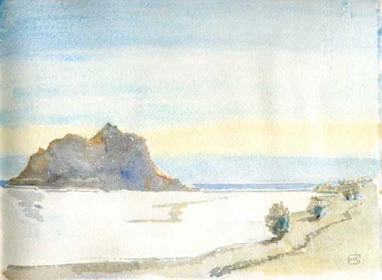
Monemvasia is a rocky peninsula that became an island following an earthquake in 375 AD. It is at the southeast extreme of the Peloponnesse. A narrow causeway now connects it with Gefyra (the extreme right of the sketch). On the island, out of sight on the far side (and indeed out of sight from the coast at any point) is the extraordinary fortified town of Monemvasia, "the Gibraltar of Greece," called Malmsey by the British and the distribution point of the famous wine of the same name. It was the commercial capital of a Byzantine province, and is gradually being restored (and touristified) by its wealthy inhabitants. The island itself reminded me of my great Quebec muse, the Percé rock.
Return to index
Scroll down to see the next one
Yeraki (or Geraki) is a town on the Laconian Plain about 40 km from Sparta. I liked the way its red-roofed houses sat on terraces that encircled its mound-like site set above the vast, blue-misted plain. The rich soil on the plain is a beautiful sienna-red; the distant mountains golden where the sun hits facets above the haze.
There is a significant ancient/medieval castle site nearby, but its entrance was chained up.
[The Indian red patches were added on to an initial very light ultramarine wash, which was then supplemented with more ultramarine, more water-mist, and some sponging to get the softness of the distant plain. The near plain, on the left, is stroked over with cerulean blue to indicate the olive groves. The town itself is painted on much drier paper, parts of which have no underpainting at all]
There was a coda of a couple of days in Heidelberg.